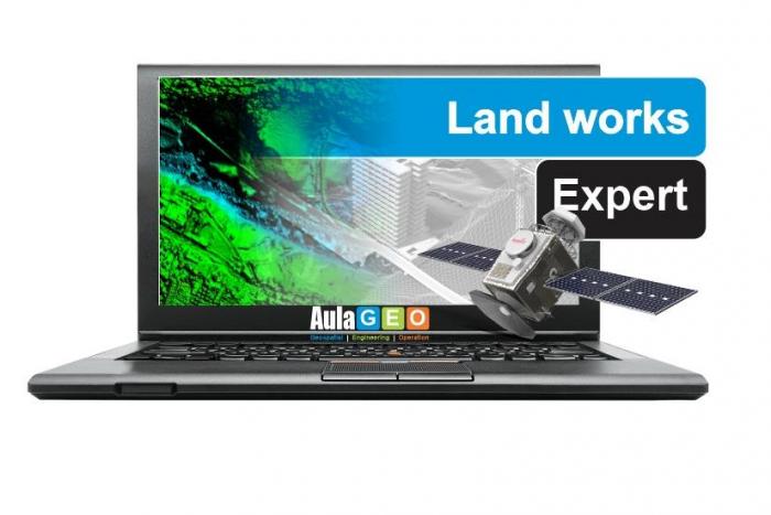
Diploma - Land works Expert

Course
Online
*Indicative price
Original amount in USD:
$ 150 $ 600

-

John Academy
Course Online£ 28 £ 247 -
One Education
Course Online£ 9 £ 425 -
Great Plains College
Course OnlinePrice on request -
Thompson Rivers University
Course OnlinePrice on request -
One Education
Course Online£ 9 £ 425 -
International Institute of Management & Engineering
Course OnlinePrice on request -
Kilroy's College
Course Distance LearningPrice on request


Take your career to the next level
-
Type
Intensive workshop
-
Level
Advanced
-
Methodology
Online
-
Duration
1 Year
-
Start date
Different dates available
-
Online campus
Yes
-
Virtual classes
Yes
¿Would you like to enhance your professional career? ¿Are you looking for specialized training and make a difference through your training? You came to the right place, Emagister presents the program "Diploma - Land works Expert" taught by AulaGEO Academy
This course is aimed at users interested in the field of remote sensing, who want to learn the tools and methods in a comprehensive way. Likewise, those who wish to complement their knowledge, because they partially master a software and wish to learn to coordinate territorial information with other cycles of acquisition, analysis and disposition of results for other disciplines.
Therefore, we encourage you to request more information, through the button attached to this website, in this way an advisor from the center will contact you to answer any questions.
Facilities
Location
Start date
Start date
About this course
- Create capacities for the acquisition, analysis and provision of spatial information
- Includes the learning of HEC-RAS, one of the most used programs in the field of water analysis
- Use of tools with which CAD / GIS data is interoperated in other disciplines such as Google Earth and AutoDesk Recap.
- Includes a practical / conceptual module for understanding the entire information management cycle from remote sensors.
- Students, researchers, professionals, and lovers of the GIS and Remote Sensing world.
- Professionals in forestry, environmental, civil engineering, geography, geology, architecture, urban planning, tourism, agriculture, biology
- Anyone who wants to use spatial data to solve geological and environmental questions.
- Consultants or professionals interested in the management of the territory, its natural risks or hydraulic management.
- Basic knowledge of Geographic Information Systems.
- Anyone interested in Remote Sensing or the use of spatial data.
- Have QGIS 3 installed
- Have ArcGIS 10 installed, and the Spatial Analyst and 3D
- Analyst extensions activated.
- Basic knowledge of hydrology
- Software management at the initiation level
- Discipline and eager to learn.
It is a different diploma because it is divided into 6 courses for better assimilation and interaction with the contents.The courses are the following shown here:
• Blender course - City and landscape modeling
• Google Earth course
• Introduction tRemote Sensing Course
• Course on flood modeling and analysis - using HEC-RAS and ArcGIS
• Flood Modeling Course - HEC-RAS from scratch
• Reality Modeling Course - AutoDesk Recap and Regard3D
You will be given all the necessary information regarding the diploma. You can also contact the AulaGEO team for any additional information. For more information see our website https://www.geofumadas.com/diplomados-aulageo/
Reviews
This centre's achievements
All courses are up to date
The average rating is higher than 3.7
More than 50 reviews in the last 12 months
This centre has featured on Emagister for 6 years
Subjects
- Remote Sensing
- HECRAS
- Google Earth
- ArcGIS
- QGIS
- Point Clouds
- Learn GIS
- Excel
- Blender modeling
- Satellite images
- 3d training
- GIS
- Hydraulic Management
- Autodesk
- Flood models
- Civil 3D
- 3D modeling
- Land Management
- Regard3D
- Meshlab
Teachers and trainers (1)

AulaGEO Academy
Specialized center in Geospatial, Engineering and Operations
We choose the best courses and make them available to new audiences in the spectrum CAD - GIS - BIM - Digital Twins Our training offer covers the entire spectrum of data intelligence: Capture - Modeling - Design - Construction - Operation. The creators of courses with which we have decided to work or promote have been carefully selected, to offer a complementary set of knowledge. We firmly believe that today people do not seek courses to fill their walls with diplomas; but to make their abilities more productive.
Course programme
- Blender course - City and landscape modeling
- Blender modeling
- Import data from OpenStreetMap Blender
- Modeling cities and surfaces in Blender
- Google Earth course
- Using the Google Earth tool from basic aspects
- Take guided tours
- Browse in 3 dimensions
- Georeference an image in Google Earth
- Download georeferenced images
- Import tGoogle Earth CAD, GIS, Excel data
- Prepare data in ArcGIS and AutoCAD for use in Google Earth
- Introduction to Remote Sensing Course
- This course guides you to learn and practice data analysis in Remote Sensing and improve your skills in geospatial analysis.
- Understand basic concepts of Remote Sensing.
- Understand the physical principles behind the interaction of EM radiation and the multiple types of ground cover (vegetation, water, minerals, rocks, etc.).
- Understand how atmospheric components can affect a signal recorded by remote sensing platforms and how tcorrect them.
- Download, pre-processing, and processing of satellite images.
- Course on flood modeling and analysis - using HEC-RAS and ArcGIS
- Carry out hydraulic studies of natural or artificial channels.
- Evaluate floodplain areas of rivers and streams.
- Plan the territory based on flood zones or hydraulic public domain.
- Perform simulations of channels or hydraulic structures.
- Incorporate the use of Geographic Information Systems (GIS) tfacilitate and improve hydraulic studies.
- Flood Modeling Course - HEC-RAS from scratch
- Know the use of HEC-RAS at the initiation level
- Understand the basic principles of hydrology and hydraulics used by the program
- Generate flooding models and interpret their results
- Reality Modeling Course - AutoDesk Recap and Regard3D
- Create 3D models using images, such as the drone photogrammetry technique.
- Use free software Regard3D and MeshLab
- Dit using AutoDesk Recap,
- Dit using Bentley ContextCapture,
- Generate point clouds
- Create surface in Civi3D from point cloud
- Clean, theming and export point cloud model,
- Share the model on the Internet using SketchFab
Additional information
Diploma - Land works Expert
*Indicative price
Original amount in USD:
$ 150 $ 600
-
John Academy
Course Online£ 28 £ 247 -
One Education
Course Online£ 9 £ 425 -
Great Plains College
Course OnlinePrice on request -
Thompson Rivers University
Course OnlinePrice on request -
One Education
Course Online£ 9 £ 425 -
International Institute of Management & Engineering
Course OnlinePrice on request -
Kilroy's College
Course Distance LearningPrice on request