GIS and Remote-Sensing, Internship Opportunity in Greece
-
You'll get to participate in a lot of projects and that's what makes this place happening. I met interesting people and had an amazing time.
← | →
Event
In Sámos (Greece)

Grow in your professional skills while helping biodiversity!
-
Type
Event
-
Level
Intermediate
-
Location
Sámos (Greece)
-
Duration
6 Months
-
Start date
Different dates available
Start your career with a special experience! Emagister presents a rewarding internship program: GIS and Remote-Sensing, offered by the Archipelagos Center, Institute of Marine Conservation.
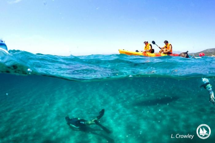
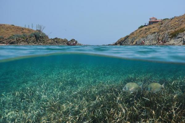
Geoinformation is an essential tool to provide answers to complex problems related to the conservation of our environment, since spatial analysis provides a better understanding of habitats and species. To achieve effective environmental preservation in the East Aegean Islands, habitats, species and threats must be mapped and studied in more detail. Through marine and terrestrial surveys, GIS Archipelagos interns collect numerous spatial data that are then evaluated for the purpose of presenting distribution models (eg, vulnerability, species, habitats).
Graduates, students and volunteers can be part of this work through an internship, which they can request in order to enrich their knowledge with the practical experience of working on field research and conservation projects. A series of key scientific conservation topics are addressed, providing participants with field research experience contributing directly to the future of this unique ecosystem.
We invite you to be part of this adventure that will help you develop your professional and personal skills. To learn more about this program, request more information through Emagister and we will contact you to provide advice.
Facilities
Location
Start date
Start date
About this course
In order to achieve effective environmental preservation in the Eastern Aegean Islands, habitats (e.g. seagrass, coralligenous reefs, wetlands), species (e.g. dolphins, whales, fish, seals, jackals, chameleons, flora) and threats need to be mapped and analysed in more detail.Through marine and terrestrial surveys, Archipelagos GIS interns collect various spatial data which is then assessed with the purpose of presenting distribution models (e.g. vulnerability, species, habitats).
Undergraduates and recent graduates of various courses related to biology, ecology, chemistry etc. as well as students, bachelors and masters of arts and media related courses.
• At least one year of college or university studies in the fields of
marine, environmental, geographical and/or related sciences
• Experience in identification of marine flora
• Experience in snorkeling, free-diving and/or kayaking
• Capacity for accurate and consistent data collection and analysis
• Comfortable working under low supervision as well as leading a
project independently
• Ability to write scientific reports and papers
• Ability to work both individually and as part of a dynamic, multi-
cultural, multidisciplinary team
Duration:
A minimum duration of 3 months is highly recommended for all participants, although shorter placements can be tailored to the needs of groups and individuals. Placements can last as long as 12 months.
Location:
Archipelagos’ research bases and stations in the eastern Aegean Sea, on the islands of Samos and Lipsi.
Placement fee:
Monthly fees of 650 euro include:
Living expenses (shared accommodation, all meals, wi-fi)
Use of equipment & research boats
Transport for working purposes
Greek language lessons
Students and recent graduates are advised to explore possible funding through their universities, by getting in touch with the Finance / International Relations / Placement/ Erasmus+ Offices at their Universities or other relevant grant providing organizations in their region.
*Travelling costs are NOT included and are covered by the participant.
Reviews
-
You'll get to participate in a lot of projects and that's what makes this place happening. I met interesting people and had an amazing time.
← | →
Course rating
Recommended
Centre rating
Student
Subjects
- GIS
- Research
- Conservation
- Field work methodologies
- Marine/terrestrial research and conservation
- Conduct surveys
- Independent/supervised research
- How to propose
- Critical Thinking
- Team Working
- Satellite images
- Kayak-based
- Boat-based surveys
- Sonar
- Multibeam
- Habitat distribution models
- Environmental Data
- Marine habitats
- Assessments
- Species
Teachers and trainers (1)

Anastasia Miliou
Scientific Director Hydrobiologist, (PhD Cand.), Fisheries Management
Course programme
- Mapping of Posidoniaseagrass meadowsthrough satellite images
- Mapping of Posidoniaseagrass meadows through kayak-based and boat-based surveys, using sonar or multibeam
- Mapping of Coralligenous reefs through boat surveys using multibeam
- Creating various species and habitat distribution models with presence/absence and environmental data (marine and terrestrial)
- Vulnerability assessments of terrestrial and/or marine habitats and species
- Exploring and developing new technologies in the Copernicus program with Sentinel-2 and 3 satellites for terrestrial and marine observation (e.g. detecting marine litter gyres in the ocean, monitoring daily environmental conditions on species presence, detecting land change etc.)
Additional information
Living expenses (shared accommodation, all meals, wi-fi)
Use of equipment & research boats
Transport for working purposes
Greek language lessons
Students and recent graduates are advised to explore possible funding through their universities, by getting in touch with the Finance / International Relations / Placement/ Erasmus+ Offices at their Universities or other relevant grant providing organizations in their region.
Travelling costs are NOT included and are covered by the participant.
GIS and Remote-Sensing, Internship Opportunity in Greece